
Understanding how to read a METAR is one of the most fundamental weather interpretation skills for pilots. As a critical component of professional flight training programs, METAR decoding allows pilots to make informed decisions based on current weather conditions. This comprehensive guide will walk you through the process of interpreting these vital aviation routine weather reports.
Key Points About Reading METARs
- METAR stands for Meteorological Aerodrome Report, which provides current surface weather information at airports. These reports are issued at each reporting location every hour and are considered valid weather information for an hour.
- The format includes the airport identifier, time of observation, wind, visibility, runway visual range, present weather phenomena, sky conditions, temperature, dew report and altimeter setting.
- Understanding METAR codes is essential for safe flight planning and aeronautical decision-making
- Wind information is used to select the appropriate runway and calculate crosswind components.
- Cloud coverage and ceiling information directly impacts VFR and IFR operation.
What is a METAR?
A METAR (Meteorological Aerodrome Report) is an observation of current weather reported in a standard international format. While the METAR code has been adopted worldwide, each country is allowed to make modifications to the code. As the primary source of current weather data for aviation, these reports provide detailed information about wind speed, wind direction, visibility, significant weather, temperature and dew point, altimeter setting, and cloud conditions.
The term METAR is derived from the French phrase "message d'observation météorologique régulière pour l'aviation", which translates to “Regular Meteorological Observation Messages for Aviation.” These standardized reports follow international protocols established by the World Meteorological Organization (WMO) and the International Civil Aviation Organization (ICAO), as detailed by the Federal Aviation Administration's Flight Service guidelines.
Why Pilots Need to Master METAR Reports
Before any flight, checking current surface weather reported is a critical step in the preflight process. METARs provide actual weather observations rather than forecasts, giving pilots the most accurate picture of current conditions at their departure, destination, and alternate airports.
During your career training, students learn that proficient METAR interpretation is essential for:
- Making safe go/no-go decisions
- Selecting appropriate runways based on wind data
- Planning for potential weather hazards
- Calculating aircraft performance based on temperature and pressure
- Meeting regulatory requirements for VFR and IFR flight
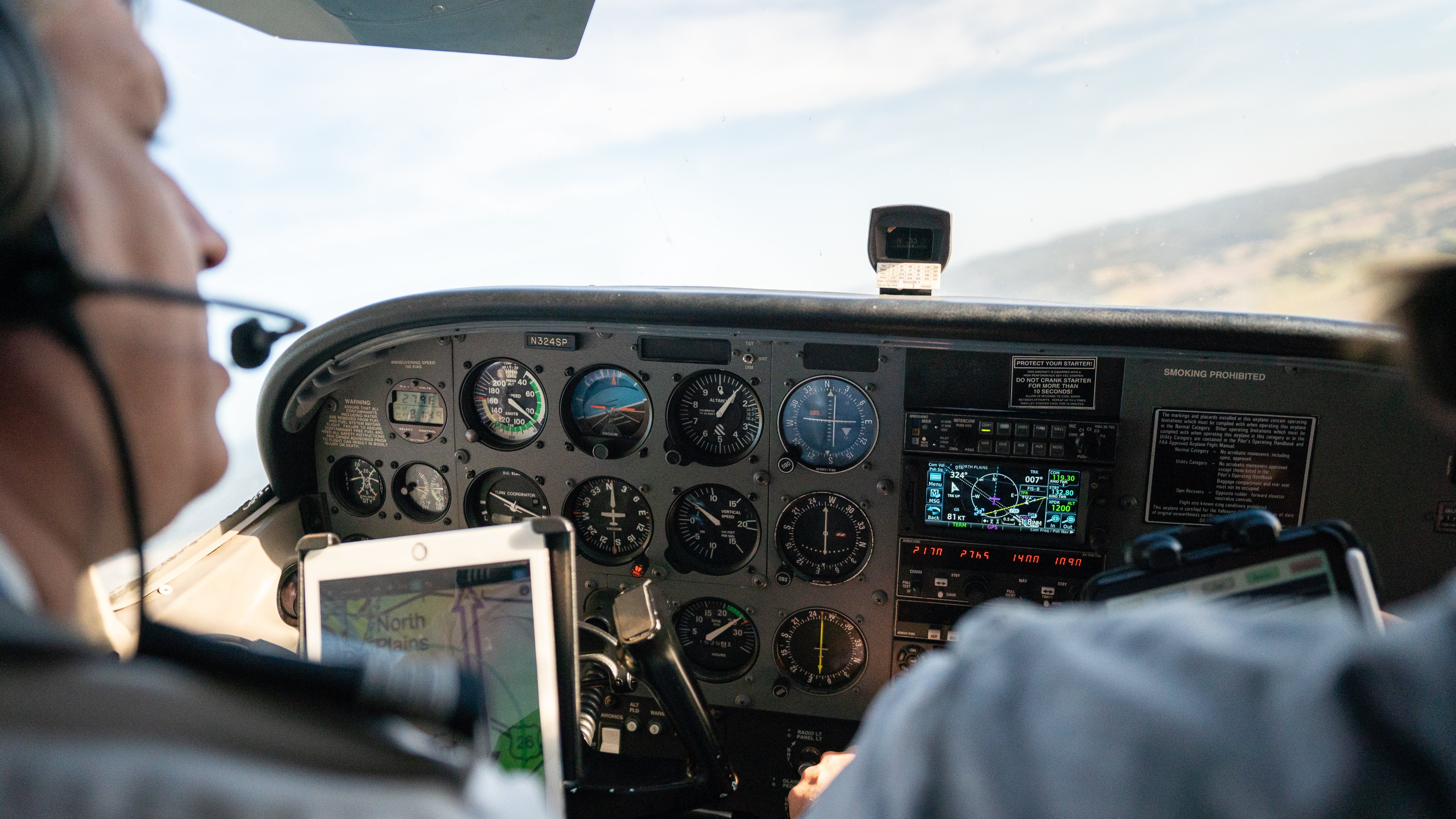
METAR Format: Breaking Down the Components
Let's break down a sample METAR report to understand each component.
METAR KMFR 281953Z AUTO 35006KT 10SM SCT120 BKN180 18/02 A2990 RMK AO2 SLP125 T01780022
1. Type of Report
There are two types of reports: the Aviation Routine Weather Report (METAR), issued at regular intervals, and the Special Aviation Weather Report (SPECI), issued when significant changes in weather conditions occur.
2. ICAO Station Identifier
The four-letter ICAO identifier indicates the location where the weather observation was taken.
In the contiguous 48 States, the 3-letter domestic station identifier is prefixed with a “K”
Example: KMFR - Medford, Oregon
3. Date and Time
The date (day of month) and time (in UTC/Zulu time) when the observation was taken.
Example: 281953Z - 28th day of the month at 19:53 UTC
4. Modifier(As Required)
“Auto” identifies a METAR/SPECI report as an automated weather report with no human intervention. If “Auto” is not present, the report was either prepared manually by a weather observer or generated automatically but reviewed and supplemented by a human.
Example: AUTO - Automated observation with no human input
5. Wind Information
Wind is reported as a five-digit group (six if over 99 knots): the first three digits show the direction, in tens of degrees from true north. The abbreviation “KT” is appended to denote the use of knots for wind speed.
Example: 35006KT - Wind from 350° at 6 knots
The wind direction provides crucial information for runway selection and crosswind calculations. For variable winds, you might see something like VRB05KT (variable direction at 5 knots) or wind direction variability notation like 350V030 (varying between 350° and 030°).
If gusts are present, they will appear as 27015G25KT - indicating wind from 270° at 15 knots, gusting to 25 knots. When a wind shear condition exists, this information is typically added after the main body of the METAR in a separate line beginning with "WS."
6. Visibility
Prevailing visibility is expressed in statue miles in the US (meters internationally).
Example: 10SM - 10 statute miles visibility
Reduced visibility directly impacts flight rules and approach minimums. Understanding visibility reporting is essential for both VFR and IFR operations.
7. Runway Visual Range(When Reported)
“R” denotes runway, followed by its heading (and designator if parallel), a “/”, then the visual range in feet (‘FT’ not spoken; meters used elsewhere)
8. Weather Phenomena
When present, this section reports precipitation, obscurations, and other weather phenomena using standard abbreviations. In METAR, weather is reported in the format:
Intensity/Proximity/Descriptor/Precipitation/Obstruction to visibility/Other
Examples:
- RA - Rain
- SHRA - Rain showers
- +TSRA - Thunderstorm with heavy rain
- BR - Mist
- FG - Fog
Weather codes provide critical information about conditions that may affect flight safety. Learning these codes is essential for proper METAR interpretation.
9. Sky Conditions
In METAR, sky condition is reported using the format :
Amount/Height or Indefinite Ceiling/Height
Example: SCT120 BKN180 - Scattered clouds at 12,000 feet, broken cloud layer at 18,000 feet
Sky conditions are reported in octas, a unit of measurement representing ⅛ of sky covered by clouds.
- SKC or CLR - Clear skies(no clouds below 12,000feet are reported)
- FEW - Few clouds (1/8 to 2/8 coverage)
- SCT - Scattered clouds (3/8 to 4/8 coverage)
- BKN - Broken clouds (5/8 to 7/8 coverage)
- OVC - Overcast (8/8 coverage)
10. Temperature and Dew Point
Temperature and dew point are reported in degrees Celsius, separated by a slash.
Example: 18/02 - Temperature 18°C, dew point 2°C
The temperature/dew point spread indicates the amount of moisture in the air and the likelihood of condensation. A small spread means the air has high moisture content and is close to saturation, suggesting a high change of fog, clouds or precipitation. A large spread means the air is dry, requiring significant cooling for condensation to occur.
11. Altimeter Setting
Altimeter settings are reported in inches of mercury prefixed with an “A” to denote the units of pressure.
Example: A2990 - 29.90 inches of mercury
Pilots use this value to calibrate their altimeters for accurate altitude readings. Internationally, this may be reported in hectopascals (hPa) with a "Q" prefix.
10. Remarks Section
Additional information that does not fit into the standard format.
Example: RMK AO2 SLP125 T01780022
Common remarks include:
- AO1/AO2 - Specifies the capabilities of automated reporting system
- SLP - Sea level pressure in hectopascals
- T - Precise temperature/dew point readings
- Weather beginnings/endings
- Precipitation amounts
- Pressure tendency
Practical Application: Using METAR Information for Flight Planning
When preparing for flight, pilots should analyze METAR reports with specific questions in mind:
- Do conditions meet VFR or IFR requirements?
- What runway is favored based on wind direction?
- Are there any hazardous weather conditions present?
- How will temperature and pressure affect aircraft performance?
- What's the trend in weather conditions?
For student pilots pursuing private pilot certification, understanding these practical applications is essential for developing sound aeronautical decision-making skills.
How to Access Current METAR Reports
Pilots can access METAR reports through various sources:
- Aviation Weather Center
- Flight Service Stations (1-800-WX-BRIEF)
- Electronic Flight Bag (EFB) applications
- Third-party aviation websites and apps
Common Challenges in METAR Interpretation
International Variations
While the basic METAR format is standardized, there are variations between countries:
- US reports use statute miles for visibility; most other countries use meters
- US reports use inches of mercury for pressure; international reports typically use hectopascals
- Some abbreviations may differ slightly between regions
Automated vs. Human Observations
Automated stations (indicated by "AUTO" in the report) have limitations:
- They may not distinguish between certain types of precipitation
- They cannot detect some cloud types (like cumulonimbus)
- They may misinterpret certain visibility conditions
According to FAA weather reporting guidelines, automated stations are classified as either AO1 (stations without precipitation discrimination capability) or AO2 (stations with precipitation discrimination capability).
Terminal Aerodrome Forecasts (TAF) vs. METAR
While METARs provide current observed weather, Terminal Aerodrome Forecasts (TAFs) predict future conditions. Pilots should understand the difference:
- METARs report actual weather
- TAFs forecast expected weather
- Both use similar coding but serve different purposes
Ready to Advance Your Weather Knowledge?
Understanding how to read a METAR is just one component of comprehensive pilot training. At Hillsboro Aero Academy, we focus on weather theory and practical application throughout our curriculum to develop pilots who make sound weather-based decisions.
If you are interested in learning more about aviation weather or starting your journey toward becoming a professional pilot, contact our admissions team today. Our admissions team will help guide you on the path to starting your career training, while our instructors will help you develop the skill set needed to interpret weather data and make safe flight decisions in any conditions once you begin training.
Frequently Asked Questions
How often are METAR reports updated?
Most major airports issue METAR reports once per hour, typically issued between 55 and 59minutes past the hour. During rapidly changing weather conditions, special METAR reports (called SPECI) may be issued between regular hourly reports.
What's the difference between METAR and SPECI reports?
METAR is the standard aviation routine weather report issued at scheduled times. SPECI is a special report issued when significant weather changes occur between regular METAR reporting times. Both use identical formats but are triggered by different circumstances.
How do I interpret wind direction in a METAR?
Wind direction in METAR reports is given in degrees relative to true north, not magnetic north. For example, 27010KT indicates wind from 270° true at 10 knots. Pilots must apply the local magnetic variation when comparing this to runway headings.
How is visibility measured for METAR reports?
At automated stations, visibility is measured using sensors that detect light scattering or absorption. At stations with human observers, visibility is determined by identifying the furthest visible objects in different directions. In the US, visibility is reported in statute miles, while most other countries use meters.
What does the "A" or "Q" prefix in the altimeter setting mean?
"A" indicates the altimeter setting is given in inches of mercury (inHg), as used in the United States. "Q" indicates the setting is in hectopascals (hPa) or millibars, as used in most other countries. For example, A2992 means 29.92 inHg, while Q1013 means 1013 hPa.
This article presents a general overview of the field of aviation, including job opportunities within that field; it does not describe the educational objectives or expected employment outcomes of a particular Hillsboro Aero Academy program. Hillsboro Aero Academy does not guarantee that students will obtain employment or any particular job. Some positions may require licensure or other certifications. We encourage you to research the requirements for the particular career you desire.